Abstract
This research deals the morphometric characteristics of the Al-Khoser river basin, which is located north of Mosul, using the GIS software to create a database for the drainage basin and convert these data into digital maps that describe the impact of its natural characteristics. Digital elevation model (DEM) was used to construct the drainage basin bounds and valley streams network, as well as to determine morphometric parameters using a series of special mathematical equations after relating them to the drainage basin's natural characteristics.
The basin is characterized by a high relief ratio of (17.23) m/km, this can be attributed to an increase in the distance between the highest point in the basin, which reached to (1238) meters and its lowest point (215) meters. And a reduction in roughness and drainage density of )2.55( and )2.5( km/km2, respectively. Different parts of the basin have different structural conditions and types of rocks. Increased erosion activity in the basin is evidence of this geomorphological activity. It has been observed that the duration, strength, and intensity of the rain that falls on the basin parts changes from the source to the estuary.
The value of the basin's form factor is (0.31), indicating that its shape is elongated, which leads to the loss of huge quantities of water throughout the long runoff period through evaporation and leakage, hence reducing the likelihood of flooding. The study suggested building a few dams on the Al-Khoser river's tributaries to store rainwater and use it to irrigate agricultural land.
Main Subjects
Full Text
1. Introduction:
The hydrological behavior is dependent on the geomorphological parameters that determine the variation in the Earth's surface from the past to the present in many areas [1]. Since the majority of basins are either unexplored or difficult to access, it has become increasingly important to study the geomorphology of basins. Morphometric studies involve the measurement and quantitative analysis of the composition of the earth's surface, its shape, and its geomorphological dimensions, taking into account the engineering and mechanical characteristics of the river basin [2], [3], [4]. The initial step in morphometric studies is the identification and monitoring of water basins [5]. The morphometric analysis shows the linear, geometric, topographic, and spatial characteristics of the drainage networks, and it requires the measurement of linear coefficients and slopes in the waterways and drainage basin [6]. In general, river drainage basins constitute a distinct morphological region with a tight relationship to the drainage pattern and geomorphology [7]. Analysis of the drainage basin in terms of its shape and size is a great way to manage and develop natural resources in a sustainable way [8].
Several previous studies have been conducted on the Al-Khoser river, including what dealt with assessing pollution from heavy elements and bacteria in the river, and the way of representing the results showed the impact of the Tigris River with the Al-Khoser river, and that this effect is dangerous up to 300 meters below the mouth of the Al-Khoser river within the Tigris River [9]. Some physical and chemical properties of the water of the mouth of the Al-Khoser river in the city of Mosul were studied, and the results of the study showed that the water of the river was affected by the amount of human, industrial and agricultural wastes that were thrown into it, which gave it greater hardness than the Tigris River water [10]. The surface runoff of the Al-Khoser river was estimated using the SWAT model for a daily period of time (2011-1991), and the results of the analysis demonstrated the applicability of this model in calculating the runoff depth and runoff coefficient of the stream [11].
The geomorphological study is an important source for defining the nature, features, and characteristics of the drainage basin, which provide important indications for water flow, amount, and velocity, which represents the hydrological component of the drainage basin valleys network. The Al-Khoser river is one of the largest seasonal tributaries of the Tigris River on Mosul's left bank, through which water flows during the rainy season, rain is the main source of surface water runoff in the Al-Khoser river basin, and the amount of running water in the basin changes from year to year and season to season, depending on how much rainfall. The primary goal of this research is to use geographic information systems technology to conduct a morphometric analysis of the basin in order to establish a spatial relationship between the forms of the Earth's surface and the water basins. In order to gain the information necessary for the interpretation of land patterns, water, and topographical drainage, this research will examine the influence of the basin's natural characteristics on the interpretation of the basin's geomorphological phase.
1.1 The study problem:
The problem of the study is to find out what effect geology, climate, vegetation, soil, and slope have on the Al-Khoser river basin's geomorphology. And does these characteristics have an impact, first, on the amount of surface water that runoff inside the drainage basin, and then, secondly, on the flooding that occurs in the city of Mosul when it rainfall?
2. Material and Methods:
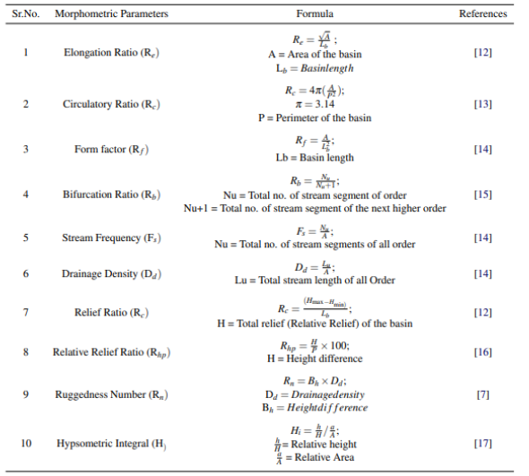
The analytical method was used to studying the morphometric properties of the Al-Khoser river basin. As these properties were derived from a series of mathematical equations (Table 1) related to the quantitative numerical statistical analysis, the foundations of which were laid by the geomorphologist Horton, in addition to using topographic maps and a digital elevation model (DEM) that was put into a set of computer software’s (Arc GIS v10.4, Arc Hydro, Global Mapper v18). The results of the analysis were then turned into accurate maps, saving time and effort that would have been needed for field work and manual calculations.
Table 1: Formulae for computation of Morphometric parameters.
3. Study Area:
The study area is situated in the middle of the Nineveh Plain and encompasses portions of the three districts (Shekhan, Al-Hamdaniya, TelKaif). Which lies between (36°49'20' - 36°21'20'') north latitudes and (43°4'40" - 43°25'20") east longitudes (Fig. 1). The basin has an area of (863.74) km2 and a perimeter of (188.46) km. The bounds of the research are represented by the drainage basin of the Khoser river, which begins to the west of the Shekhan district, precisely in Ba'dara on the outskirts of Mount Maqloub, flows south towards the city of Mosul, and enters the Tigris River in the Al-Faisaliah region.
The study area has a Mediterranean climate, which means that the summer are very hot and dry, while the winter are cold and wet. Temperatures change during the year's seasons, as well as during the night and day, as they decline from September until January, when they reach their lowest point, and then steadily increase until they reach their maximum point in July. Due to the high temperatures and low relative humidity during summer, the rate of evaporation increases. And the amount of precipitation that falls during the winter and spring seasons varies from one year to the next.

Fig. 1: Location of study area.
3.1 Geology of the basin:
The flow of the water of the Al-Khoser river is on the left bank of the Tigris River from its source to its estuary within the city of Mosul and on the surfaces of many geological formations detectors. The rocks exposed Al-Khoser river basin are represented by sedimentary formation to quaternary periods. the following is abrief description of the geological formations oldest to the youngest, and they are the Pilaspi Formation (Middle and Upper Eocene), which consists of calcified limestone rocks with the presence of a part of the green marl in the upper direction, and the Gercus Formation (Middle Eocene) located at the top of the basin consisting of sandstone and mud, and the formation of the Fat'ha (Middle Miocene) which consists of irregular sedimentary cycles of marl, limestone and evaporated rocks. and mudstone, and the Bai Hassan Formation (Early Pliocene), which consists of successive conglomerate with sandstone, silt and shale [18], and the Muqdadiyah formation (Late Pliocene), which consists of a succession of soft claystone, gray sandstone, brown and gray silt and shale stone and is often covered The modern sediments, as well as the sediments of the Quaternary age (Fig. 2).

Fig. 2: A geological map of the study area.
3.2 Basin Slope:
The slope map of the study area was derived from the digital elevation model (DEM) with a discriminatory accuracy (14) meters, and based on the classification [19], which falls into five classification levels as shown in Fig. (3), the northern side of the basin is characterized by being steeper From the southern side due to the presence of some mountains, as for the middle of the basin, it is almost plain and flat lands with some ripples and bends, due to the presence of small and seasonal valleys that fill with water in the rainy season as their drainage is towards the main valleys that drain their water into the Tigris River, as it spreads in the middle of The basin is some individual hills and table heights as a result of its exposure to severe erosion, and it is noticed that about (65%) of the drainage basin area is plains.

Fig. 3: A map showing Zinck's classification of slope levels.
3.3 Rainfall:
Al-Khoser river is one of the seasonal runoff rivers, and rain is the most important water sources, especially in the winter and spring seasons. As the amount of rain increases and its abundance, the water level rises in the river basin, and the speed of its flow and the river drains of the water increase. and the less precipitation, the lesser the water and the decrease in its level to a degree that sometimes reaches the point of drought in the summer season. It was based on data acquired from the website (Data Access Viewer - NASA POWER) for the period between (2001-2021) and for seven climatic stations, and according to Fig. (4), there is no consistency in the annual rainfall rates falling on the Al-Khoser river basin, as it ranged between (354-378) mm at the top of the basin (the upstream region) and then gradually decreased towards the mouth of the river, ranging between (254-279) mm.

Fig.4: The annual rainfall distribution map for the basin.
4. Results and Discussion:
4.1 Shape and area characteristics:
The importance of the river basin area as a morphometric variable is represented through its effect on the volume of water drainage inside the basin, and there is a direct relationship between the area and the drainage basin, as the larger the basin area, the greater the numbers and lengths of the river network and its effect on the volume of water drainage [20]. The Arc GIS software was used to get the areal characteristics of the Al-Khoser river basin, which are shown in Table (2).
Table 2: The areal characteristics of Al-Khoser river basin.
|
No. |
Characteristics |
The value |
|
1 |
Basin area (km2) |
863.74 |
|
2 |
Perimeter of the basin (km) |
188.46 |
|
3 |
Basin width (km) |
16.53 |
|
4 |
Basin length (km) |
52.24 |
|
5 |
Main stream length (km) |
45.23 |
4.1.1 Elongation Ratio:
The ratio of elongation indicates the approach of the shape of the basin from the rectangular shape, and its ratio ranges between (0-1). Whenever the value approaches zero, it indicates the elongation of the shape of the basin. The shape of the basin close to the rectangle is characterized by its high relief, which affects the hydrological processes prevailing in the drainage basin [21].
The value of the elongation coefficient of Al-Khoser river basin was (0.56). This value indicates the elongation of the basin and the irregular spatial distribution of the basin, and that the basin penetrates various and heterogeneous geological formations. The nature of the drainage in this basin is less than the basins of circular shape or close to the circular shape, due to the length of the stream at the expense of its width and then the loss of large quantities of water during the long runoff.
4. 1.2 Circulatory Ratio:
The circulatory ratio is measured by dividing the area of the basin by the area of a circle having the same circumference [13]. The circulatory coefficient values range from (0-1). High values (greater than 0.5) indicate that the shape of the basin is close to the circular shape. The circulatory ratio of Al-Khoser river basin was (0.30), which is a low value indicating the basin’s divergence from the circular shape, and that the basin is still at the beginning of its erosion activity, In addition to the retrograde erosion in the first-order tributaries, which is responsible for the expansion of the basin area, the river deepens and excavates its path vertically.
4.1.3 Form Factor:
It is calculated from the quotient of dividing the area of the basin by the square of the length of the basin [14], and its value is always less than (0.754) for the circular basins [22]. This parameter gives an indication of the extent of consistency between the parts of the drainage basin and the regularity of the general shape for him, it also highlights the relationship between basin length and width. The value of the form factor of Al-Khoser river basin was (0.31), and it is considered a low value, which indicates its distinction in its length and the variation in the ratio significantly between its length and width, and this indicates the smallness of the area versus the length of the basin. This basin experiences a lower peak flow velocity for a longer period because it is elongated.
4.2 Draining characteristics:
The study of the drainage characteristics of the basins is very important in determining the basin morphology. The data of Al-Khoser basin drainage network was measured using a digital elevation model (DEM) with a spatial resolution of (14) meters. The drainage basin was extracted after determining its downstream point by using the hydrology tools included in the Arc GIS software, such as; fill tool, flow direction tool, flow accumulation tool, stream tool, and stream order, as shown in Fig. (5).

Fig. 5: Methodology for the extraction of the basin drainage network; a- Digital elevation model, b- Fill, c- Flow direction, d- Flow accumulation, e- Streams, F- Stream order.
4.2.1 StreamOrder:
There has been reliance on the classification [7] for stream order, whereby a system for classifying stream order in which the basic small streams into which no other streams flow are like first-order streams, the meeting of two first-order streams makes a second-order stream, and so on, and the main stream represents the highest rank in the drainage basin. The drainage basin of Al-Khoser river varies in its river streams due to the reflection of the topographical situation on its streams in addition to the different geological structure of the basin. Accordingly, the number of stream orders of the basin is six, and the volume of water discharge from the river tributaries increases with the increase in its order [23].
4.2.2 Stream Length:
The total length of the streams of Al-Khoser river basin reached (2,158.34) km, distributed among the orders according to Table (3), as the streams of the first order formed (51.30%) of the total length of the streams of Al-Khoser river basin, and the streams of the second order formed (25.68%) Consequently, the first and second orders together occupy about (76.98%) of the total lengths of the streams of the basin due to the increase in the number of streams of both orders, noting that there is an inverse relationship between the sum of the stream lengths and the stream order of the river.
Table 3: The Stream Lengths of Al-Khoser river basin.
|
Order |
Length (km) |
The ratio % |
|
1 |
1107.12 |
51.30 |
|
2 |
554.40 |
25.68 |
|
3 |
262.17 |
12.15 |
|
4 |
151.16 |
7 |
|
5 |
38.26 |
1.77 |
|
6 |
45.23 |
2.1 |
|
Total |
2158.34 |
100 |
4.2.3 Stream Number:
There is an inverse linear relationship between the stream order and the stream number. It is evident from Table (4) that the total number of streams of Al-Khoser river basin reached (2772) streams, and that most of the river streams fall within the first and second order, with a percentage (94.83%) of the total streams.
Table 4: The stream numbers in each order.
|
Order |
1 |
2 |
3 |
4 |
5 |
6 |
Total |
|
Stream Number |
2199 |
430 |
115 |
21 |
6 |
1 |
2772 |
4.2.4 Bifurcation Ratio:
The bifurcation ratio represents the relationship between the number of streams in an order and the number of streams in the next order. The value of the normal bifurcation ratio of the basin ranges between (3-5) if the rock composition of the basin is homogeneous [7]. The average percentage of bifurcation in Al-Khoser river basin is (4.76), as it is within the normal limits, as shown in Table (5).
Table 5: the values of the bifurcation ratio for the orders in Al-Khoser river basin.
|
Order |
1-2 |
2-3 |
3-4 |
4-5 |
5-6 |
Average bifurcation ratio |
|
Value |
5.11 |
3.74 |
5.47 |
3.5 |
6 |
4.76 |
The bifurcation ratio in Al-Khoser river basin is close to the upper limit set by (Strahler), indicating the severity of the basin being cut by the streams, and thus the risk of flooding in the basin is reduced, as the water disperses before it reaches the main course, which is the Tigris River.
4.2.5 Stream Frequency:
Stream frequency refers to the relationship between the total number of streams in the basin divided by the area of the basin [24]. The frequency of streams is affected by the natural factors of the basin, especially the climate. The stream frequency is an indicator of the density of drainage in the basin. It indicates to the vertical and lateral erosion of the valley streams, where erosion increases with the increase of the stream frequency.
The value of the stream frequency of the basin was (3.21) stream/km2, this value is considered as medium, it indicates to the steepness of the slope and the high value of the relative relief and that it runs over heterogeneous rock formations. This value indicates to the small number of the basin streams compared to its area, and that the basin is at the beginning of its geomorphological cycle.
4.2.6 Drainage Density:
Drainage density is one of the important morphometric measures of the river drainage network, and it is a reflection of the climatic conditions, especially rainfall and its amount, the geological characteristics, the type of rocks and their permeability, the surface and its slope, and the nature of vegetation cover [25]. The values of the drainage density of Al-Khoser river basin were (2.5) km/km2, and this value is considered very low, according to [7] classification, as he classified the drainage density values into three categories: (less than 12) low, and (12-16) medium, and (greater than 16) is high.
Low drainage density in the Al-Khoser river basin can be attributed to the lack of precipitation and its seasonality, as well as the permeability of the surface. This lack contributed to the ineffectiveness of water erosion, the cutting of the surface of the area with water streams, the few numbers of streams and their short lengths in the basin. The low drainage density suggests that the flood did not develop in a geomorphological important way.
4.3. Relief characteristics:
4.3.1 Relief Ratio:
The relief ratio is an important criterion for determining the topographical characteristics of a specific area, it expresses the range of basin relief in relation to its length and increases with decreasing area and volume of basin drainage [26].
The relief ratio in the basin is equal to (17.23) m/km, which is considered a high percentage. The reason for the high value of the rocks coefficient in Al-Khoser river basin is the increase in the difference between the level of the highest point and the lowest point in the basin, as well as the variation in the structural conditions and the type of rocks on the parts of the basin, as indicated by the geomorphological activity of the basin, and thus increased activity erosion in the basin.
4.3.2 Relative Relief Ratio :
Relative relief refers to the interrelationship between the molar value (the difference between the level of the highest and lowest point in the basin) and the perimeter of the basin in percentage terms. It affects many variables in the basin, the most important of which are the hydrological characteristics and the drainage density. The low values of the relative relief indicate the weak resistance of the rocks and the activity of erosion agents in the basin [27].
The ratio of the relative relief of Al-Khoser river basin was (0.48). This ratio indicates that the relative relief of the basin is high. The high value of the relative relief indicates the severity of the relief and ruggedness of the basin surface, and that the basin is still in the early stages of its geomorphological cycle.
4.3.3 Ruggedness Number:
The value of ruggedness is an important morphometric parameter that measures the relationship between basin relief and drainage network density [28], as well as an indicator of the extent of the basin progress in the geomorphological cycle. The value of the ruggedness of Al-Khoser river basin is equal to (2.55), the value was considered low. The reason for the decrease in the ruggedness value of the basin is due to its low drainage density. A lower roughness value indicates that the basin is at the beginning of its geomorphological cycle.
4.3.4 Hypsometric Integration:
It is considered a time scale as it aims to determine the geomorphological stage that the drainage basin passes through. Hypsometric integration is used to explain numerically the relationship between the basin area and its height, the value of the hypsometric parameter decreases with the continuous progression of the basin’s erosion cycle. To determine the stage the pelvis is going through, (Strahler) divided the value of the hypsometric integration into categories as follows: (less than 40) aging, (40-60) maturity, (60-80) youth. It was found that the hypsometric integration of Al-Khoser river basin is equal to (56%). Thus, it becomes clear that the basin is undergoing an early maturity stage, meaning that the basin is at the beginning of its geomorphological cycle.
5. Conclusions
1- GIS technology has shown to be an accurate and efficient tool for identifying the drainage basin and analyzing its morphometric properties.
2- The morphometric characteristics of Al-Khoser river basin are related to the hydrological characteristics represented by the parameters of the climate, especially rainfall, in addition to soil, rocks, vegetation cover and slope.
3- Rainfall varies in volume, duration, and intensity across the basin from its source to its mouth in the estuary.
4- According to the slope map, (65%) of the area within Al-Khoser river drainage basin consists of plains.
5- Al-Khoser river basin is characterized by a high rate of elongation and a low of form factor. Therefore, the basin has a low peak flow velocity over a longer period because it is characterized by elongation, and this increases the chance of water exposure to evaporation and reduces the likelihood of floods.
6- The shape of Al-Khoser river basin is close to the rectangle, and this is reflected in the length of time the water arrived from the source to the outlet.
7- The bifurcation ratio of Al-Khoser river basin is close to the upper limit set by (Strahler), indicating that the drainage basin is interrupted by the streams, and thus the risk of flooding in the basin is reduced, as the water disperses before it reaches the main stream.
8- Al-Khoser river basin has a low drainage density due to its small number of valleys relative to its size, its permeable surface, and its low slope.
9- The value of the relief ratio in Al-Khoser river basin is high due to the variation in structural conditions and the type of rocks on the parts of the basin.
10- The value of hypsometric integration was (56%), and this reflects the age and erosional stage, which represents the early maturity stage.
6. Recommendations
1- Establishment of some small dams on the canals of Al-Khoser river, in order to store the water resulting from the falling rains in the winter and spring seasons, and to use them to irrigate the cultivated areas.
2- Establishing stations to measure the discharge of water drainage before reaching the Tigris River to regulate the flow of water and predict the risk of floods in the future.
3- Use modern technologies and advanced programs in the study of adjacent basins in the future for the purpose of comparison with the current study to reach more accurate results in morphometric studies.
Funding: None.
Data Availability Statement: All of the data supporting the findings of the presented study are available from corresponding author on request.
Declarations:
Conflict of interest: The authors declare that they have no conflict of interest.
Ethical approval: The manuscript has not been published or submitted to another journal, nor is it under review.
)